Geology 1A����������������������������������������������������������������������������������������� West Valley College
Physical Geology��������������������������������������������������������������������������������������������� R. Lopez
Point Lobos Marinos Field Trip:
Carmel, CA
Objectives: Geologic mapping by topographic inspection of geological units at Point Lobos State Reserve, Carmel, California. Using a topographic base map, we will locate our positions by inspecting the local topographic contours, pacing, and compass direction. At each station, we will record data on (1) lithology and (2) geologic structure. At some stations, we will also complete a sketch map or drawing of the geologic field relationships.
Outcomes: By the end of this day, you will have participated in the romantic side of geology, Field Geology. There is no better place to do your work than the outdoors (this is why most geologist pick exotic islands or tropical beaches to do their field geology).
Products: You will produce a geologic map with marked field stations, lithology contacts, geologic structures. You will depict the different rock units in the area mapped with colors (Red for Santa Lucia Granodiorite; Blue for the Carmelo Formation; Brown for marine terrace deposits). Your map will have a legend form oldest to youngest units (Santa Lucia Granodiorite = 80 to 100 Ma; Carmelo Formation = 60 Ma; Marine Terrace Deposits = 1.6 Ma to Recent). You will also take legible and careful notes in a field notebook. This notebook will include descriptions of each geologic unit and geologic structure in the field area. Finally, your notebook will also include the sketches or drawings of the lithology contacts and structures.
Final Report Your final product will be a geologic map and accompanying geologic history written report (2-3 pages). You will turn in a (1) complete geologic map with legend, (2) written geologic history (2-3 pages), (3) notebook with field stations and sketches.
Materials Needed:
Pencil
Colored Pencils
Ruler (protractor)
Compass
Clipboard or Hardback Binder
Field Note Book
Lunch
Water
Rain Poncho
Backpack
Warm Clothes
Boots/Tennis Shoes
Hat
Sunglasses
Sunscreen
Meeting Times and Directions: Pt. Lobos Field Trip
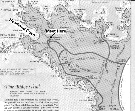
Our field trip is scheduled for Friday, April 15, or Saturday, April 16. We will meet at 10:00 AM, and I expect to have the project completed by 3:00 PM. Our meeting point is the Headland Cove parking area. There is an information booth there (see map below).
Driving Directions: ������ Take CA HWY 85 south to US HWY 101 in south San Jose
����������������������������������� Follow
US HWY 101 south to CA HWY 156 west to Monterey
����������������������������������� Take HWY 156 to CA HWY 1 at Castroville, CA
����������������������������������� Follow CA HWY 1 south past Monterey to Carmel, CA
����������������������������������� Pt.
Lobos State Reserve is just past Monastery Beach
����������������������������������� off of CA HWY 1 on ocean side of road.
����������������������������������� There is a $5.00 per vehicle charge.
����������������������������������� Allow 1.5 hours for driving time (don�t get lost!)