Ocean
10�������������������������������������������������������������������������������� West
Valley College
R. Lopez
����������������������������������������������������������������������������������������������� NAME_________________
Field Trip Exercise: Natural Bridges State Park
BEACHES AND THE LONGSHORE CURRENT
Beach =
Longshore current =
Wave Refraction =
Rip Currents =
HEADLANDS, SEA CLIFFS, SEA STACKS, AND WAVE-CUT PLATEFORMS
Headlands =
Sea Cliffs =
Sea Stacks =
Sea Arches =
Marine Terraces =
Wave-Cut Platform =
Marine Terraces
Marine Terraces =
Wave Cut Platform =
The Santa Cruz Mountains have experienced considerable tectonic uplift.� This uplift has elevated marine terraces along their flank.� So the older marine terraces were formed underwater in the surf zone before uplift of the Mountain.� To give you and example of the rate of uplift, during the 1989 Loma Prieta Earthquake, the Santa Cruz Mountains were elevated by four feet in some areas.� Over time, enough of these earthquakes can really change the elevation of the coastal areas.
There
are five relatively well preserved marine terraces along the coast between
Santa Cruz and Ano Nuevo State Beach. We will see the three youngest on our
field trip.
Youngest (lowest):������ Santa Cruz terrace (*)
����������������������������������� Western terrace (*)
����������������������������������� Wilder terrace (*)
����������������������������������� Black Rock terrace
Oldest (highest):��������� Quarry terrace
The marked ones are visible from Natural Bridges State Park.
Santa Cruz Terrace � underlies West Cliff Drive, Mission Street, and Highway 1.� The shore-angle elevation is about 100 ft (elevation of the terrace at the old sea cliff).� Age about 100 Kyr (Pleistocene) � recent work suggests that this terrace is 60 Kyr.
Western Terrace � the hill on Western Drive
is the old sea cliff between the Santa Cruz terrace and Western Terrace. (shore
angle is about 280 ft.).� Age = about
200 Kyr.
Wilder Terrace � after Wilder creek.� The ancient sea cliff for the Wilder Terrace
is the small hill between the main entrance of the UCSC campus and the lower
entrance to the bike path.
Black Rock � is about 570 ft high, age
about 430,000 years
Quarry Terrace � is about 720 feet high,
age 550,000? Years
Rocky
Intertidal Community
We
will investigate the high, middle, and low tide zones.� For this project, you will identify a
variety of organisms and classify them based on Phylum, Class (if possible),
and location in intertidal zone plus type of habitat within the zone.� Record your data on the table below.� We are identifying algae, marine plants, and
all organisms.
Vertical Distribution of
Intertidal Life
��������������������������������������������������������������������������������������������������������������� Intertidal
Zone�������������������� Habitat
in Zone
|
Species (Common
name) |
Phylum |
Class |
Upper |
Middle |
Low |
Flat Area |
Tide Pool |
Wall |
|
|
|
|
|
|
|
|
|
|
|
|
|
|
|
|
|
|
|
|
|
|
|
|
|
|
|
|
|
|
|
|
|
|
|
|
|
|
|
|
|
|
|
|
|
|
|
|
|
|
|
|
|
|
|
|
|
|
|
|
|
|
|
|
|
|
|
|
|
|
|
|
|
|
|
|
|
|
|
|
|
|
|
|
|
|
|
|
|
|
|
|
|
|
|
|
|
|
|
|
|
|
|
|
|
|
|
|
|
|
|
|
|
|
|
|
|
|
|
|
|
|
|
|
|
|
|
|
|
|
|
|
|
|
|
|
|
|
|
|
|
|
|
|
|
|
|
|
|
|
|
|
|
|
|
|
|
|
|
|
|
|
|
|
|
|
|
|
|
|
|
|
|
|
|
|
|
|
|
|
|
|
|
|
|
|
|
|
|
|
|
|
|
|
|
|
|
|
|
|
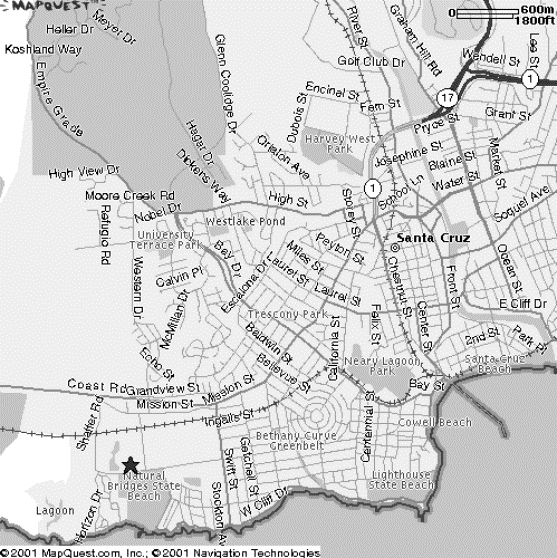
Directions to Natural
Bridges State Beach in Santa Cruz
� HWY 85 South from West
Valley College
� HWY 17 South to Santa Cruz
� HWY 1 North (in Santa Cruz)
� Follow signs to Half Moon
Bay � San Francisco on HWY 1
� HWY becomes Mission Street
in Santa Cruz
� Continue on Mission Street
to intersection at Swift Street (stop light)
� Turn Left onto Swift Street
(going toward ocean)
� Turn Right at the stop sign
onto Delaware Ave.
� Drive down on Delaware to
BACK GATE of Natural Bridges State Beach
� Park along Delaware Ave. at
the back entrance to the park
� Meet group at the back gate
entrance.